ITDP India

Promoting sustainable and equitable transportation worldwide

  • Contact
  • Who We Are
    • Our Approach
    • ITDP India’s 2024
    • Contact Us
    • Career Opportunities
  • What We Do
    • Healthy Streets
    • Public Transport
    • Electric Mobility
    • Transit Oriented Development
    • Low Emission Zones
    • Inclusive Mobility
    • Traffic Reduction
  • Where We Work
    • NATIONAL
    • MAHARASHTRA
      • Pune
      • Pimpri Chinchwad
      • Nashik
    • TAMIL NADU
      • Chennai
      • Coimbatore
    • JHARKHAND
      • Ranchi
    • Agra
    • Ahmedabad
  • Blogs
  • Resources
  • National Challenges
    • India Cycles4Change Challenge
    • Streets for People Challenge
    • Transport4All Challenge
  • Urbanlogue
    • Urbanlogue Webinars – Series One
    • Urbanlogue Webinars – Series Two
    • Urbanlogue Webinars – Series Three
    • Urbanlogue Webinars – Series Four
  • Press

In Chennai, Our Cities Ourselves Focused on People, Parking and Density

17th December 2013 by admin

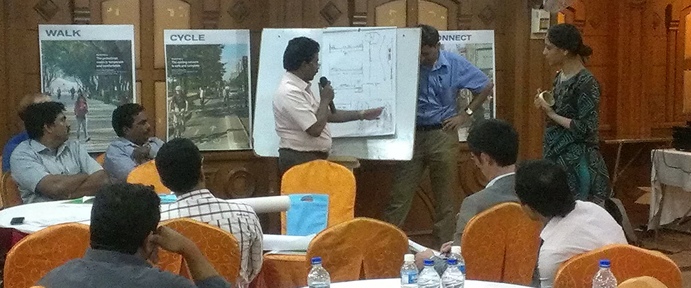
“Cities are for people,” said Mr. Phanindra Reddy, a Municipal Secretary of the Chennai Metro Rail (CMRL) in the state of Tamil Nadu, India, “this is the mantra we have to keep in mind when we do our work.” This sentiment was echoed by keynote speaker, city planner and educator Peter J. Park, and Senior Town Planner Neela Munshi of the Ahmedabad Urban Development Authority, at ITDP’s Our Cities Ourselves workshop in Chennai, India.

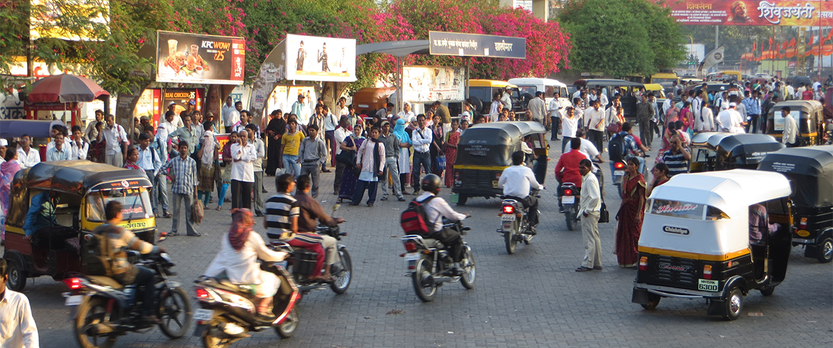
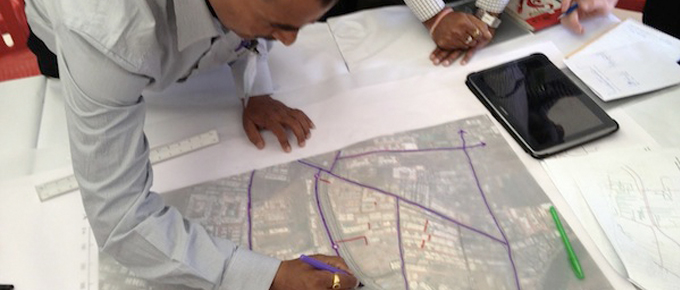
The workshop, “Enabling Transit-oriented Development”, focused on station area planning around the Koyembedu metro station, set to be the first to open when Chennai metro rail begins operation within the next three years. Peter Park opened the workshop with an overview of international best practices in TOD, and discussion of his work as a city planner for the cities of Denver and Milwaukee. This included increasing neighborhood density, creating more infrastructure for cyclists and pedestrians, and reforming land use codes to allow for less parking and more walkable, accessible places around transit. One project that piqued quite a bit of interest was Park’s removal of a flyover in Milkaukee, and his demonstration and encouragement of highway removal in other cities around the world. This was of significant interest in Chennai, as flyovers are a common sight, and building more of them is often considered inevitable.


Ms. Neela Munshi gave an engaging presentation on the planned transformation of Ahmedabad, which boasts India’s most high quality bus rapid transit system – Janmarg. New land use regulations allow for greater density in the city’s central business district, new affordable housing provisions and reduced parking requirements. Ahmedabad abolished lot coverage requirments to enhance the public realm by bringing buildings closer to property lines. The city now also grants density bonuses to developers who wish to build more density around transit, which will help pay for streetscape improvements.

Mr. Kumar Rajaraman, Managing Director of Chennai Metro Rail, noted that the visions produced as part of Our Cities Ourselves showing new footpaths and dedicated bus lanes is the kind of forward-looking planning that is missing in Chennai. “People need to imagine what the future of Chennai can be, and work to make it better,” said Mr. Rajaraman.

OCO Chennai is a workshop series and exhibition supported by ClimateWorks Foundation and Volvo Research and Educational Foundations, that offers solutions to support walking, cycling, and mass transport options for a more sustainable future.

Filed Under: news Tagged With: Chennai, Complete Streets, Traffic reduction, Transit Oriented Development, Walking and Cycling

Related News

  • Chennai adopts NMT Policy: A quantum leap towards safer streets

    October 21, 2014

  • Chennai Celebrates Walking at the Sustainia Award Ceremony

    February 4, 2016

  • Whose city is it anyway? A people and transit-oriented approach to city building

    September 20, 2014

More News >

Everything is Everywhere: Land Use in India

Cities_Nashik_cover

12th March 2013 by admin

Indian streets are a messy mix of people, cyclists, rickshaws, taxis, cars, buses, even the occasional cow. But within this mess is the vibrancy and fluidity of street life, like a tasty street soup where seemingly unlikely things come together and strange things might be bobbing around. Land use is India is similarly messy and mixed, and also creates a vibrant street life where activities are located close to one another and it is easy for someone to find what they need within walking distance. Everything is everywhere, it seems.

Land use zoning in India is Euclidean based, meaning it creates land use classifications (i.e. residential, multi-family, commercial) by geographic area, but instead of keeping those uses separate, land use in Indian cities typically builds off of the uses in one zone to create a more integrated approach. For example, in Chennai, the first land use category, primary residential, allows residential, as well as cottage industries, petty shops, small farms, and schools of commerce. The mixed residential zone allows everything that was allowed in primary residential, as well as banks, restaurants, shops, bakeries, etc.  The commercial land use zone allows everything in primary residential and mixed residential, and then some.  And so it builds.

According to ITDP’s Eight Principles for Transport in Urban Life mixed uses is one component of good urban development.  If India has mixed use down, what, then, is the main issue for zoning in India? For Indian cities, the two biggest issues as represented by the Eight Principles are density and connectivity.

How should we define density in dense environments like Indian cities? The floor area ratio (known as floor space index in India) is usually set at a uniform and low rate across the city.  Indian cities are using transfer of development rights (TDR) to encourage densification in certain areas, but those areas are often at the outskirts of the city center.  Essentially, TDR is being used to not really densify new areas, but to de-densify the crowded centers.  This may be resulting in sprawl and not in focusing growth in strategic ways, like around transit.

Planning typically is done by the state, not the city, and only looks at main arterials.  The smaller streets and the connections within an area are often missing.  So while land use zoning fosters everything everywhere within walking distance, the connections to make that happen – the micro street grid – may be missing, especially in new areas. And given the growth of Indian cities, we want to make sure that the new areas have the vibrancy of the older areas – where the streets are vibrant places in their own right and help us go everywhere – where mixed uses, density, and connectivity create good places where we want to be.

Filed Under: news Tagged With: Transit Oriented Development

Related News

  • Envisioning a Comprehensive Transport Plan for Chennai

    January 28, 2013

  • Delhi plans for smart growth around transit

    August 18, 2015

  • InFocus: Building transit-oriented cities

    March 16, 2015

More News >

Transit-Oriented Development in Pimpri Chinchwad

7th March 2013 by admin

by C. Ranga Rohini, ITDP India

With an urbanization rate of over 40 percent in the Indian state of Maharashtra, planning authorities and public transport operators face the increased responsibility of providing efficient transport systems while improving the quality of urban life. Pimpri Chinchwad, one of the state’s fastest growing cities, is set to open the first two corridors of a planned 40 km bus rapid transit (BRT) network in early 2014. To ensure that as many residents as possible can benefit from the BRT, the city has begun exploring mechanisms to achieve greater harmony between land use regulations and the emerging mass rapid transit system.

Officials of the Pimpri Chinchwad Municipal Corporation (PCMC) recognize that there is an urgent need to transform existing urban landscapes from a collection of free-standing structures into a cohesive urban environment centered around high quality public transport. Developing a strong framework to guide future growth is essential to achieving this vision. For this purpose, ITDP partnered with PCMC to orgnaize a one-day workshop on transit-oriented development (TOD). The workshop brought together planners, engineers, and other senior officials with experts from ITDP.

Luc Nadal, ITDP’s Technical Director for Urban Development, presented on the link between urban form and transport mode choices. He emphasized the need to create compact, permeable neighborhoods, citing international examples such as Central Saint Giles Court in London, IJburg in Amsterdam, and Quartier Messana in Paris. Luc also introduced ITDP’s TOD Standard as a tool to assess urban developments located near public transport nodes. For the purpose of the workshop, the ITDP team analysed a 1.2 square kilometre study area centered around three BRT stations in Pimpale Saudagar to identify existing issues and to assess the changes required in the urban fabric to facilitate transit-oriented development.

TOD-Pimpri-Chinchwad-03

Pratibha Bhadane, Senior Town Planner, PCMC, presents a proposal to use parking restrictions within 400 m of BRT stations to spur private “parking markets” outside the BRT influence area.

Participants addressed the following topics in three groups:

– Transit-oriented land use planning at the city level. The group explored mechanisms for aligning job density and infrastructure growth along BRT corridors with projected residential growth. The group also discussed the role of off-street parking reforms and affordable housing as means of promoting the use of public transport.

– The street network and the public realm. Group members identified opportunities to prioritize non-motorized and public transport modes, create an interlinked network of public spaces, and finance these projects through street management mechanisms.

– Built form in the private domain and its interface with the public realm. This involved the identification of preferred building typologies and forms that contribute to the public domain as well as institutional mechanisms to enforce these proposals. Viable financial mechanisms were also developed to route revenue from TOD areas to fund infrastructure improvements in the region.
TOD-Pimpri-Chinchwad-04

Assessing walkability in Pimple Saudagar: poor street connectivity limits the catchment area of the BRT system. The green area represents the actual 5 minute pedestrian catchment area within the ideal 400 m buffer around three stations.

Participants agreed that denser development should be planned in the 400 m catchment areas along BRT and metro corridors in order to ensure that the majority of the 740,000 new residents expected to move to Pimpri Chinchwad over the next decade can find accommodation within walking distance of a mass rapid transit station. Participants also developed strong proposals for parking policies to reduce use of private motorized vehicles and incentives for inclusive development through the provision of smaller, affordable units on the BRT corridors.

In terms of better connectivity to station areas, they agreed on the need to restrict block sizes and create a dense network of high quality, safe walking and cycling streets lined by vibrant commercial and residential edges. Implications of increased density on physical and social infrastructure need to be assessed. In addition, participants identified a need for better financial analysis of development rights systems. There was also consensus among the participants on the need to consolidate existing rules and validate existing assumptions through a pilot project in the region. The workshop marks a milestone in the land use and transport planning for Pimpri Chinchwad and has paved the way for second round of discussions among private developers, resident welfare associations, and other stakeholders in the region.

Filed Under: news Tagged With: Pune-Pimpri Chinchwad, Traffic reduction, Transit Oriented Development

Envisioning a Comprehensive Transport Plan for Chennai

28th January 2013 by admin

by C. Ranga Rohini, ITDP

With a population of over 4.7 million and with a rapidly growing economy, the city of Chennai faces the challenge of providing efficient, safe, and reliable transport solutions to its citizens without compromising on quality of life. The onus of this responsibility currently falls on a number of agencies in the city and brings with it a slew of issues in planning, coordination, and accountability. The Chennai Unified Metropolitan Transport Authority (CUMTA) was formed in November 2010 with the aim to address these issues—to serve as a single nodal agency that directs planning, operations, and monitoring of various transport modes in the metropolitan area of Chennai. One of CUMTA’s key responsibilities is the preparation of a Comprehensive Transport Plan that looks at the planning and development of public transport options and their implementation through various agencies.

To facilitate this process, CMDA, in collaboration with the Institute of Transport and Development Policy, organized a workshop from 22 to 24 January 2013 that brought together various government stakeholders along with experts and academicians to discuss the CUMTA’s vision and to develop viable strategies and actions to carry the vision forward.

Participants formed groups to deliberate on four primary topic areas: 1) CUMTA as an agent of change for the Chennai Metropolitan Area: defining CUMTA’s role as a planning, monitoring, and coordinating body to facilitate interagency coordination. 2) Developing an integrated, high quality bus and BRT network for the entire city: expanding the bus fleet, implementing BRT, introducing an integrated fare collection systems across modes, and providing customer information. 3) Improving streets and the public realm: developing pedestrian friendly street design standards and planning guidelines, identifying greenway networks, and improving intermodal links. 4) Management of road space and travel demand: implementing a robust on-street parking management system, facilitating compact development around public transport stations, and implementing dynamic road pricing solutions.

At the workshop, Mr. Ben Plowden, Director of Surface Transport at Transport for London, described the city of London’s experience in bringing multiple public transport providers under a single umbrella, starting in 2000. He showed how London has been able to achieve a reduction in the use of private cars over the past decade through the steady expansion of sustainable transport options, including expanded bus service and a network of high quality cycle tracks. “You need a transport system that is adequate to meet the demands that the city will put on it,” pointed out Mr. Plowden. “That means focusing on mass transit.”

Workshop attendees included representatives from CMDA, the Corporation of Chennai, Chennai Metro Rail Limited, Highways Department, Transport Department, TNRDC, Metropolitan Transport Corporation, consultants, NGO Chennai City Connect, faculty from the Indian Institute of Technology, Madras, School of Architecture and Planning, Anna University, and representatives from unified metropolitan transport authorities in Bangalore and Delhi, among others.

To achieve the vision of transforming Chennai into a world-class city, a general consensus was reached on the need to assess existing resources, identify short-term goals, and focus on early wins to build CUMTA’s reputation. Participants stressed the role of data collection in enabling evidence-based planning and identified a need for a financial audit of existing spending patterns. “Data collection is critical,” explained Mr. K. Phanindra Reddy, Secretary of the Department of Housing and Urban Development, Government of Tamil Nadu. “Unless we know the scenario we are starting with, and the lacunae that we need to address, we will be groping in the dark.”

A key initiative to emerge in the workshop’s action plan is the creation of a common information portal for all public transport modes in Chennai. Geographically focused, time-bound pilot projects on pedestrianization, parking, street design, and multi-modal integration were also identified. ITDP has begun compiling the outcomes of the workshop into a strategic plan to be adopted by CUMTA. “The stakeholders have come out with each and every suggestion,” said Mr. Reddy. “That is a critical element for success of CUMTA. It’s time that we turn our plans into assets on the street.”

Comprehensive-Transport-Plan-02

Ensuring that all Chennai residents have access to high quality public transport was a key theme during the workshop. Shown above are the areas within a 5 minute walk of public transport.

Comprehensive-Transport-Plan-03

Charrette participants debated on the potential role of CUMTA in ensuring coordination among Chennai’s transport system operators.

Comprehensive-Transport-Plan-04

Participants discussed the importance of balancing the “link” and “place” functions of streets, using Chennai’s Saidapet area as a case study.

Filed Under: news Tagged With: Chennai, Public Transport, Transit Oriented Development, Walking and Cycling

  • « Previous Page
  • 1
  • 2
  • Who We Are
    • Our Team
    • Contact Us
    • Opportunities
    • Our Approach
  • What We Do
    • Complete Streets and Parking Management
    • Public Transport
    • Transit Oriented Development
    • Inclusive Mobility
  • Where We Work
    • Agra
    • Ahmedabad
    • MAHARASHTRA
    • Pune – Pimpri-Chinchwad
    • Nashik
    • TAMIL NADU
    • Chennai
    • Coimbatore
    • JHARKHAND
    • Ranchi
    • NATIONAL
  • News
  • Resources
  • Get Involved
    • Donate

Copyright © 2025 · ITDP Responsive on Genesis Framework · WordPress · Log in


Loading Comments...